Off-road convoys lose each other, and cell towers don't help
Group off-road trips through Northern Pakistan routinely cover terrain with no cellular signal for hours at a stretch — mountain passes, riverbeds, forest tracks. Vehicles spread out, someone takes a wrong turn, and there's no way to know who's where until everyone happens to regroup at the same waypoint. WhatsApp location sharing simply stops working the moment signal drops, which is exactly when you need it most.
The requirement wasn't "build a tracking app" — plenty exist. It was build one that keeps working when the network doesn't, and that syncs cleanly the instant a bar of signal reappears.
A convoy app that assumes the network will fail
Kafila is a installable PWA where every vehicle's phone queues its own GPS trail locally and pushes it to the group the moment connectivity allows. The map (MapLibre GL over free Protomaps vector tiles) shows live positions, trails, and distance travelled for every member of the convoy, plus SOS alerts, waypoint checkpoints, geo-tagged trip notes, and refuel logging.
A public no-login "watch" link lets family back home follow the convoy live without an account — important for trips where the whole point is that someone worries.
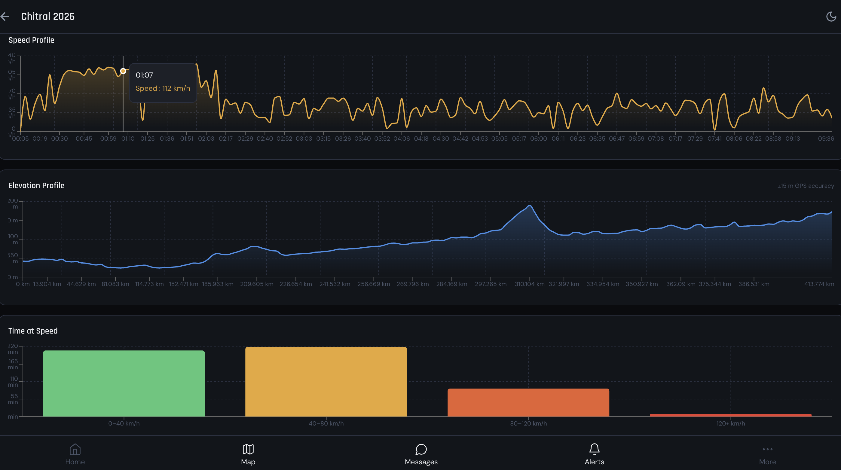
Post-trip analytics for a completed convoy trip — speed profile, elevation profile, and a time-at-speed breakdown, reconstructed entirely from the queued GPS trail.
Built around one hard constraint: no signal, no problem
Under the hood
| Frontend | React 18 + Vite + Tailwind + Zustand, installable PWA |
| Maps | MapLibre GL JS + Protomaps vector tiles (free, no rate limits at this scale) |
| Offline | Dexie.js (IndexedDB) GPS queue with a persistent sync engine |
| Backend | PHP 8.1 + MariaDB on Hostinger shared hosting |
| Media | Cloudinary (alert/POI photos), SendGrid (SOS email) |
| Auth | JWT with access + refresh token rotation |
Where it stands
Phase 1 — auth, convoy creation/joining, live GPS tracking, and the map — is complete and live, and post-trip analytics (speed, elevation, time-at-speed) already ships too. Phase 2 (messaging, SOS, checkpoints, Garmin) is backend-ready; POIs and trip replay are planned for future trips.